Sites to explore
The Kingston and Arthur's Vale Historic Area (KAVHA) has been recognised for its outstanding Georgian buildings and evocative ruins. Major structures at KAVHA include:
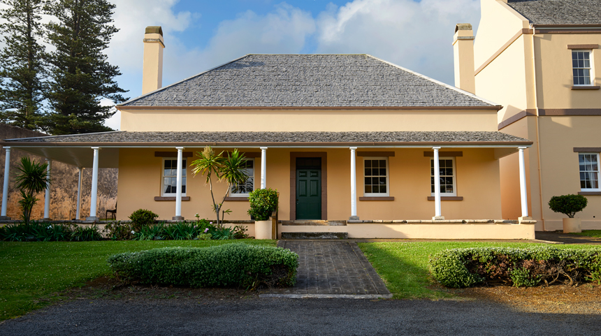
Government House
The 1829 Government House is remarkably intact. With its commanding views of the settlement, the house is still used as an official residence for the Norfolk Island Administrator.
Open days at Government House raise money for local charities.

Front of Government House. Photograph: Rob Nisbet
Old Military Barracks and Officers' Quarters
Constructed between 1829 and 1834, the Old Military Barracks and flanking officers' quarters are surrounded by high compound walls giving it an appearance of a military fortress. Ancillary buildings include the former officers' outbuilding, officers' privy, guard room, powder magazine, military hospital and wells. In 1855 the main barracks became a Methodist Church with the first floor and the unstable upper (third) storey removed and a new gable roof added.
From 1979 to 2015, the buildings were the home of the Norfolk Island Legislative Assembly. Today the Court House can be found on the ground floor.

Aerial photograph of Old Military Barracks. Photograph: Gregg Brotherston

Officers quarters at Old Military Barracks. Photograph: Rob Nisbet
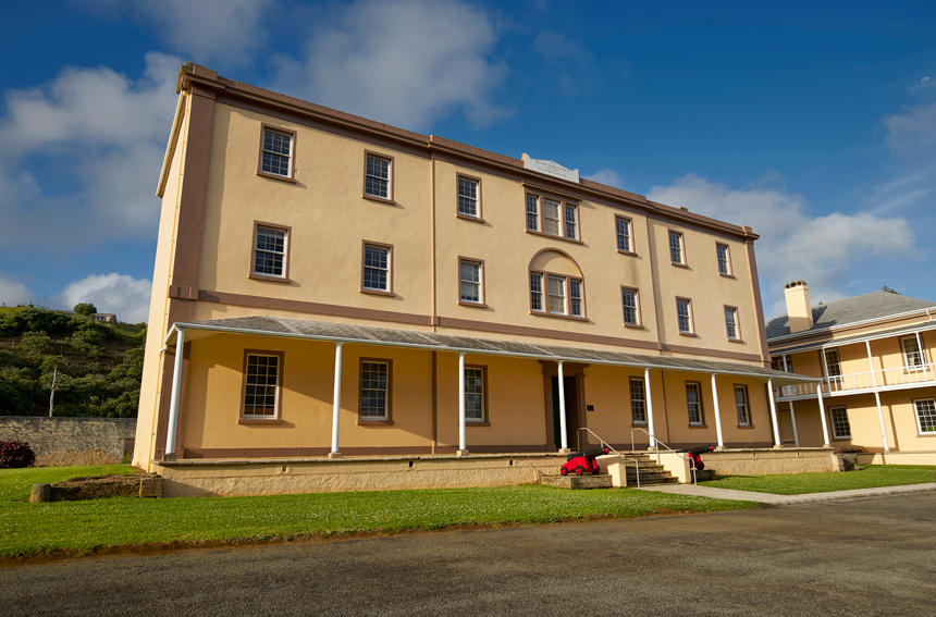
New Military Barracks
This complex, constructed between 1835–1837, has a larger central barracks flanked by officers' quarters (reconstructed after a fire) and the archaeological remains of a military hospital. The officer's outbuilding became a lock-up c. 1910. The compound wall, including the main archway and corner turrets, survives. In 1856, Pitcairners initially lived in the barracks.
The school was on the second floor from 1856 to 1911, and the Pitcairners' courtroom (built in 1896) was on the ground floor. In 1926, buildings in this compound were extensively renovated for the administration of Norfolk Island.

Front of New Military Barracks. Photograph: Rob Nisbet
The Commissariat Store
The Commissariat Store building is largely intact with stone walls, timber internal floors, roof structure and the impressive front stair. On the parapet is a dedication to Major Anderson. It originally consisted of three floors and a basement.
When the building was converted into an Anglican Church in 1874, the main or lower floor ceiling was removed to create a double height space and a stained glass window was added. The basement is now used for the Norfolk Island Museum's archaeological collection.

Commissariat Store. Photograph: Rob Nisbet
Quality Row houses
In 1832–1847, 11 residences were built as officer's quarters. Following the arrival of the Pitcairn Islanders, houses were allocated to Pitcairn families by a lottery. While a number of the original houses have been destroyed by fire, the remaining houses form an impressive streetscape.
Today, No. 10 Quality Row is a house museum, No. 9 is a research centre and No. 1 is the golf clubhouse. Some are preserved as ruins, while others are residences.

Aerial photograph of KAVHA, overlooking Quality Row.
Photograph: Rob Nisbet
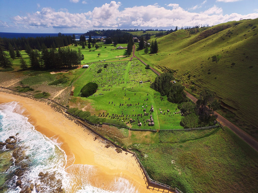
Cemetery Reserve
The cemetery has been in use since c. 1798. The initial area has a stone gate, corner posts and memorials of calcarenite. Unusually, it includes headstones for convicts.
After 1856, the cemetery extended west and marble headstones were used. Further east, on land that was at that time unconsecrated ground, is Murderers' Mound—the unmarked burial site of members of the 1846 convict uprising.

Aerial photograph of Norfolk Island cemetery. Photograph: Rob Nisbet

Convict-era headstones at Norfolk Island cemetery. Photograph: Australian Government
Bloody Bridge
This stone bridge was constructed on the road to Ball's Bay in the mid-1830s. A section of the stone wall collapsed c. 1910 and was not reconstructed in the same alignment. The road over the bridge was sealed c. 1960. Place names—in particular, Bloody Bridge, Quality Row and Gallows Gate—appear to date from this period.

Bob Dewey, Music Valley, Bloody Bridge — Henry Spencer-Salt, 1935.
Source: National Library of Australia (Bib ID 2010819)
The Wreck of the HMS Sirius
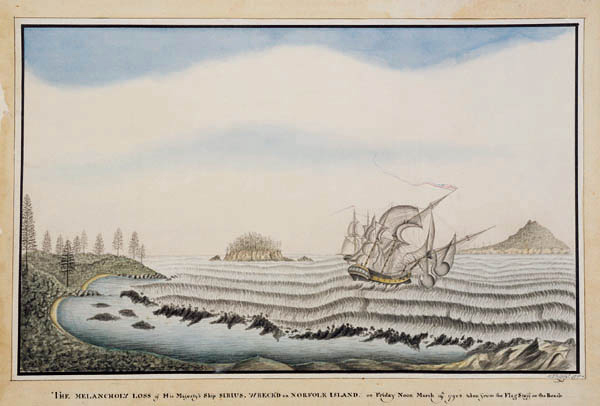
On 19 March 1790 HMS Sirius, flagship of the First Fleet, was wrecked off the reef at Slaughter Bay on Norfolk Island. Approximately 6,000 artefacts were recovered during official expeditions between 1983 and 2002. Some of the more significant objects that were recovered are displayed in the Norfolk Island Museum, including an anchor. Two more anchors are on mainland Australia, including at the Australian National Maritime Museum.
The HMS Sirius shipwreck site is on the coral reef just outside of the KAVHA site.

The Melancholy loss of His Majesty’s Ship Sirius, wrecked on Norfolk Island — George Raper, 1790.
Source: National Library of Australia (Bib ID 361598)
Other archaeological remains
The archaeological remains of the two convict gaols, and the perimeter walls and archaeological remains of the prisoners' barracks (1828–48) next to the Protestant chapel can also be found at KAVHA. These show the development of penal philosophies during the period of the settlement's operation.
Other archaeological remains include the blacksmith's shop (1846), lumber yard, water mill, the Crankmill (1827–38), the salt house (1847), the windmill base (1842–43), lime kilns, the landing pier (1839–47) and sea wall.

The Crankmill building. Photograph: Rob Nisbet

Remains of the New Gaol at the KAVHA site. Photograph: Rob Nisbet
